Collective documentation
Analyzing environmental degradation
Yevheniia Berchul, Katja Knecht, Olaf Mumm, Vanessa Miriam Carlow
ISU — Institute for Sustainable Urbanism, Faculty of Architecture, Civil Engineering and Environmental Sciences, Technische Universität Braunschweig, Germany
Keywords: participatory documentation, armed conflict, crowdsourced data, environmental degradation
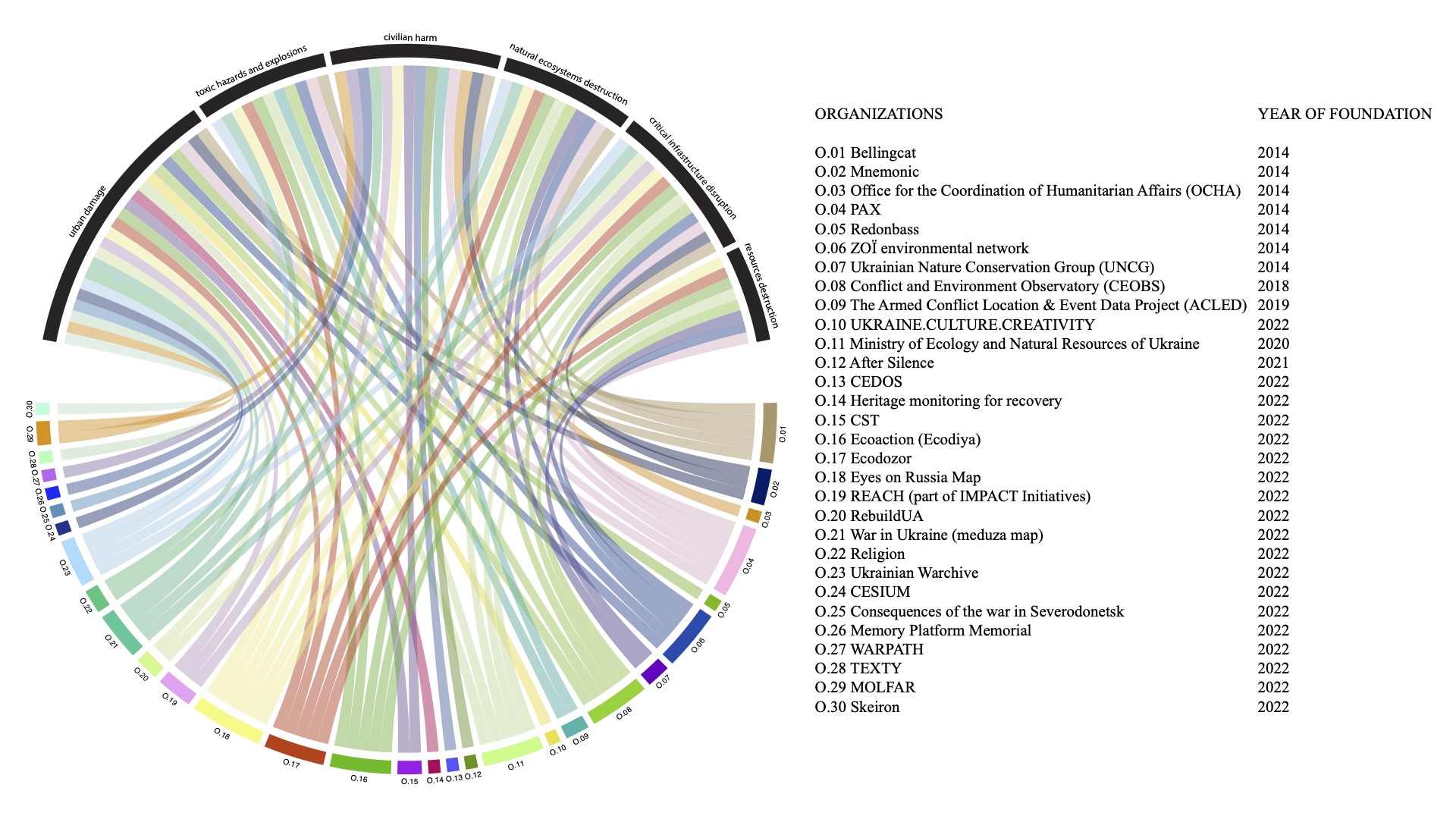
Emerged network for collective documentation of the war in Ukraine, © Institute for Sustainable Urbanism
Abstract
Ubiquitous digitization allows people to cooperate and participate in the documentation of destructive impacts on the living environment and ecology caused by armed conflicts. Focusing on cities and urban regions, these collaborative processes play a vital role in assisting the analysis of urban damage and helping to mitigate long-term environmental degradation. Moreover, by leveraging the data-driven approaches, urban society can contribute to developing and adopting strategies for sustainable and livable (re)development of the cities during and after conflict. However, given the numerous limitations associated with data collection in the context of ongoing hostilities, there is a need to explore collaborative approaches to documenting the effects of environmental damage. The presented work examines how socio-technical progress empowers communities to employ diverse methods for monitoring and analyzing the damage to urban and natural landscapes in the context of armed conflicts. Using the ongoing war in Ukraine as a case study, this paper explores emerging mechanisms and tools for collaborative practices integrated within a set of institutions and initiatives with expertise in monitoring and analyzing environmental issues. The presented research focuses on identifying technological innovations that offer ample opportunities for public participation in urban research and spatial analysis — from the real world to accessible data points. Ultimately, this paper aims to contribute to a better understanding of how digital tools can promote co-creation methods to investigate environmental issues and how these practices can facilitate and support architectural and urban planning fields.
Introduction
Ongoing armed conflicts raise significant public concerns regarding extensive damage to both human living conditions and natural ecosystems. This damage encloses the widespread destruction of industrial and civil infrastructure, contamination of air, water and soil, and the devastation of natural ecosystems, including fires and marine pollution. These implications have serious long-term ecological consequences and ultimately contribute to long-term environmental degradation.1 Fostering public awareness and engagement in documenting such violent conflicts has emerged as an effective approach to comprehensively analyze the extent of damage to urban and natural environments.2 Technological advances, digitization, and the availability of mobile devices are increasingly facilitating the ability to document damage while conflicts are still ongoing, and thus democratize access to data and tools for analyzing the negative impacts. This comprehensive documentation of the destructive effects on the urban environment within mapping platform developments can later support post-war reconstruction.3 Since the beginning of the Russian aggression against Ukraine, various forms of public documentation have emerged across a range of digital platforms, media, and institutional sources.4 These developments offer the potential to be further expanded to establish more efficient networks for data utilization and spatial analysis of affected areas and contribute to reconstruction in post-conflict conditions. By leveraging the data-driven approaches, digital developments with public participation can impact the development and adaptation of strategies for sustainable regeneration of the living environment during and after conflict. In response to the destructive consequences of the war in Ukraine, the Digital Restoration Ecosystem for Accountable Management platform was designed to provide a wide information network between civil society, government, communities, and businesses for reconstruction efforts.5 Based on public participation and open data, these new platform developments can drive new ways for public cooperation in urban practices and maximize ecological concerns in planning sectors.
This research is dedicated to identifying current methods of public participation in the documentation of environmental damage, leveraging spatial technologies and mapping platforms. This paper focuses on an examination of the data and tools integrated into collaborative documentation practices. Specifically, we attempted to understand the potential of emerging mapping platforms to support the fields of architecture and urban planning, offering open access to data resources and involving a diverse range of stakeholders. In pursuit of this goal, we reviewed practices related to data collection and sharing organized through mapping and other digital platforms oriented toward spatial analysis in conflict-affected regions of Ukraine. This review enhances discussions on urban analysis and socio-technical opportunities that emerged in response to violent conflicts. By analyzing emerging approaches and methods for collaborative documentation, we seek to contribute to understanding the potential of open data platforms for the sustainable (re)development of urban and natural territories affected by the war in Ukraine.
Open mapping platforms
Existing map providers and platforms, such as Google Maps or Open Street Map, allow everyone to produce customized interactive maps that, e.g. focus on a particular type of information or a specific geographical area. During the war in Ukraine, many mapping platforms were developed for the designation of damaged objects and registration of war crimes. Citizens can contribute information directly by uploading images and descriptions through web platforms. Different kinds of thematic maps have been created in Ukraine that allow the collective mapping of cultural heritage damage,6 information on damages to residential buildings and urban infrastructures,7 and other warfare impacts on the environment.8 Citizens can also contribute knowledge through interviews, social media information, and exchanging data remotely. In particular, local knowledge can strengthen the research on temporary-occupied territories where access to damaged buildings and infrastructure is limited. Official information on environmental destruction can also be verified through satellite imagery, one such example is the “Environmental Damage Map” launched by Greenpeace Central and Eastern Europe (CEE), together with Ukrainian NGO Ecoaction [Екодія].9 The information is categorized into different types of environmental impact, such as damage to industrial facilities, energy safety, ecosystem disruption, marine ecosystems, and nuclear safety. The most serious environmental damage is mapped to assist in future planning and financing of future nature restoration in Ukraine.
Archive platforms
Digital platforms have emerged as invaluable tools for gathering spatial data related to cultural heritage, historical monuments, and various architectural structures. These platforms can integrate data leveraged by technologies like photogrammetry to capture and utilize architectural information for future reconstruction as well as investigative purposes. One such example is the Mariupol Drama Theater’s digital archive, developed by the Center for Spatial Technologies.10 This archive compiles media materials and a precise reconstructed 3D model of the theater to provide a detailed investigation of the theater attack. Researchers employ the digital platform to facilitate collective investigative practices, allowing in-depth examinations and the consolidation of insight and testimonies obtained from interviews. This platform serves as a digital memorial, curated through contributions from individuals connected to the event and their eyewitness accounts. Digital archives can be well-established for creating a comprehensive database of architectural materials of historical and cultural heritage that can be used in the future for detailed reconstruction. For instance, Skeiron utilize photogrammetry techniques to archive detailed architectural models that can serve in future as the basis on which detailed working drawings can be performed.11 This archived collection of scanned and digitalized architectural objects is a valuable tool for contributing detailed architectural dimensions to rebuilding damaged objects. Moreover, by creating data archives, initiatives ensure that valuable evidence is documented and made accessible for analysis, research, and advocacy purposes. For example, MNEMONIC has archived open data to ensure the availability, findability and traceability of data for the development and implementation of redundant repositories and the description of metadata.12 These measures are fundamental for ensuring the long-term preservation and accessibility of valuable metadata for research and reference purposes. Moreover, it facilitates data integration, comparability, and sharing, leading to more comprehensive and insightful assessments of urban and natural damage.
Damage assessment
Platforms for damage assessment collection have emerged to measure the negative consequences of warfare orienting on social needs and local priorities. Diverse organizations and international initiatives such as IMPACT and REACH initiatives have produced Rapid Needs Assessments and Building Damage Assessments in different conflict-affected regions of Ukraine with the goal to examine settlements and provide an understanding of the situation across a wide range of sectors and conflict impacts.13 Although the situation is changing fast, damage assessment methods are widely used in conflict contexts to provide an estimation of the local situation in a particular time frame. Reports based on damage assessments usually provide recommendations and mitigation strategies for addressing environmental damage and humanitarian losses. The RebuildUA initiative has recorded and digitized the damage and destruction of the infrastructure with the main purpose of attracting funding for the reconstruction of the affected territories. Therefore, the RebuildUA platform presents loss evaluations, visual information on damage and other information for communication regarding different regions affected by Russian aggression in Ukraine.14 This platform can contribute to public understanding of environmental damage on a larger scale, inform decision-makers, and advocate policy changes or actions to promote sustainable recovery.
The potential of collective documentation in addressing environmental degradation
In the context of armed conflicts, digital platforms have emerged as a prevalent means of engaging civil society in documenting the negative effects on ecosystems and designating areas of concern. These developments possess the potential to enhance the analysis of environmental impacts on a broader scale by tracking changes in urban and landscape dynamics over time. Establishing such collaborative networks maintains a sustainable approach to integrating valuable data and resources related to sustainable reconstruction and fostering innovative data-driven urban planning. These collective methodologies promote new opportunities for civil societies, local communities, creative sectors, governmental organizations, and various specialists to collaboratively contribute to the revitalization of both cities and natural ecosystems. These platforms, along with open data, have the capacity to exert transformative influences on urban planning methodologies, particularly in cities grappling with conditions during and after armed conflicts.
References
- Hook, Kristina, and Richard Marcantonio. 2022. “Environmental Dimensions of Conflict and Paralyzed Responses: The Ongoing Case of Ukraine and Future Implications for Urban Warfare.” Small Wars & Insurgencies, February, 1–29. https://doi.org/10.1080/09592318.2022.2035098. ↩︎
- Weir, Doug, Dan McQuillan, and Robert A. Francis. 2019. “Civilian Science: The Potential of Participatory Environmental Monitoring in Areas Affected by Armed Conflicts.” Environmental Monitoring and Assessment 191 (10): 618. https://doi.org/10.1007/s10661-019-7773-9.
Zwijnenburg, Wim, David Hochhauser, Omar Dewachi, Richard Sullivan, and Vinh-Kim Nguyen. 2020. “Solving the Jigsaw of Conflict-Related Environmental Damage: Utilizing Open-Source Analysis to Improve Research into Environmental Health Risks.” Journal of Public Health 42 (3): e352–60. https://doi.org/10.1093/pubmed/fdz107. ↩︎ - Saldarriaga, Juan Francisco, Laura Kurgan, and Dare Brawley. 2017. “Visualizing Conflict: Possibilities for Urban Research.” Urban Planning 2 (April): 2183–7635. https://doi.org/10.17645/up.v2i1.880. ↩︎
- Bojor, Laviniu, and Alin Cîrdei. 2023. “The Challenges of Social Media Platforms. Aspects of the Social Media War in Ukraine 2014-2022.” Land Forces Academy Review 27 (January): 296–301. https://doi.org/10.2478/raft-2022-0037. ↩︎
- “DREAM”, Digital Restoration Ecosystem for Accountable Management, accessed September 25, 2023, https://dream.gov.ua. ↩︎
- “hemo”, Ukrainian Heritage Monitoring Lab, access September 25, 2023, https://www.heritage.in.ua; “UACulture”, Map of Cultural Losses, accessed September 25, 2023, https://uaculture.org/en/. ↩︎
- “Sievierodonetsk”, war impacts in Severodonetsk 2022, accessed September 25, 2023, https://www.google.com/maps/d/u/0/viewer?mid=18b6U3beisS-irDxmTGP8p0xwrtvQ-7E&hl=en_US&ll=48.93988157403391,38.49245713173507&z=13 ↩︎
- “Eyes on Russia Map”, accessed September 25, 2023 https://eyesonrussia.org/ ↩︎
- “Environmental damage map”, Ecoaction [Екодія] and Greenpeace Central and Eastern Europe (CEE), accessed September 25, 2023, https://maps.greenpeace.org/maps/gpcee/ukraine_damage_2022/ ↩︎
- “ Mariupol Drama Theater”, The Center for Spatial Technologies, accessed September 25, 2023, https://theater.spatialtech.info/ ↩︎
- “SKEIRON”, accessed September 25, 2023, https://skeiron.com.ua/ ↩︎
- MNEMONIC, accessed June 26, 2023, https://ukrainianarchive.org/en/investigations ↩︎
- “Rapid Needs Assessment (RNA) of Conflict-Affected Areas”, IMPACT Initiatives & the REACH Initiative, accessed September 25, 2023, https://www.humanitarianresponse.info/en/operations/ukraine/document/reach-rapid-needs-assessment-conflict-affected-areas-eastern-regions-6 ↩︎
- RebuildUA, accessed September 25, 2023, https://rebuildua.net/ ↩︎